
A phone’s sense of place is always changing, which brings fresh possibilities on how you can utilise those devices. That location-aspect is what makes me interested in creating apps for phones and one way I’ve pushed forward interest is in making an unofficial app with a week-long summer event. Each August 6,000 young people camp together at Newday for a week of worshipping God, helping the surrounding community with the love they have for it, listening to talks, and just having fun around the tents. Although it’s not the same scale as Mikel at Burning Man, the organisers of this event are equally like city planners and install road signs for the zones and districts they create.
 My first app for Newday was before smartphones, I recompiled an existing j2me app with the site data I had surveyed for OpenStreetMap (and some custom rendering rules). The phone tethered with a £30 GPS dongle over bluetooth, because that’s how you had to do geolocation in 2007. A few versions later and the 2012 app was compiled with Phonegap to make it available to download for Android or Blackberry phones (I didn’t deem it worth buying an Apple developer license). The map part used custom tiles that had the camping zones & meeting venues pre-drawn on them.
After a 2013 hiatus from the event, I returned again this year. In the weekend before the event I decided to revive the app but as a more simple mobile-focused website. In true tradition I had inadequate time but coded away for the thrill of developing my skills and trialling or reinforcing recent technology. For the first time I reused old code, although didn’t get onto replacing the poor design. To enable future code reuse I got it onto version control & uploaded publicly to Github so others could contribute if desired. I was keen to do that and would particularly be interested in mentoring any of the young delegates to get more interested in programming.
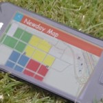
 I added the event-specific information as geojson files, which these days is much more suitable for displaying and for managing updates. The camping zones are displayed in their respective colours and venues such as the cafe of temporary big top are displayed in another colour. I even added an auto-complete text box where you can search for a church and find their specific camp site, although it’s still unofficial and I only had the information of 10 churches before heading to the event. The use of git version control did allow me to add to the geojson files using my tablet “in the field” but my time was better spent in water fights than recording hundreds of church camp sites. Although it’s a web app, almost all the code is javascript to limit server-side code. This makes will make it easier to once again be available to install on major phone systems (even from the app stores) and for it to run offline if required.
There are visions for next year’s release if I work on it again, some of which could be added by other programmers. Due to my work this year I shouldn’t need to start from scratch again. The timetable feature could return, letting you know which meetings are up next or in the remaining days. I also have thoughts on a multi-player treasure hunt game where the app either directs you to hide a clue or bible passage in a location or it asks you to find one that has been hidden by another player. Another new feature was a direct-line(suitable for flying crows) satnav to camp sites & event locations, I may look at adding navigation that follows the roads including use of paths that only exist for the duration of the event. There are lots of possibilities depending how much time I spend on it, so maybe next year I’ll dedicate some work hours in the name of employee training.